GungasUncle
I've spent the last hr or so putting together a google map of fishing spots and places to check out - and zoomed around looking at different river systems. Something has set my blood boiling, and there's nothing I can really do about it.
Thanks to Google Maps satellite view - you can clearly see that there's clear cut operations going on right up at the head waters of the Tualatin, Gales Creek, the Lewis & Clark and Youngs rivers - and a number of other rivers. I'm not against timber cutting, or clear cutting for that matter - but it burns my arse that they cut so close to the streams. It's proven that these streams need a wider buffer zone - so when I see the tell tale signs where the guy lines for a yarder have been placed and trees drug through - it burns my butt. It's pretty easy to tell when you're looking at the map - the landings are a little clear spot with arrow straight spider legs coming off of them, and you can clearly see on Gales Creek, where they've not only cut up to the creek in places, but they're running wires over the creek.
It doesn't matter that these streams may only be a few feet wide up there - that's where the stream begins and it's important to the health of the stream. Choking the head waters with sediment and mud from a clear cut sure is not the way to a healthy stream. And what happens when the rain comes?
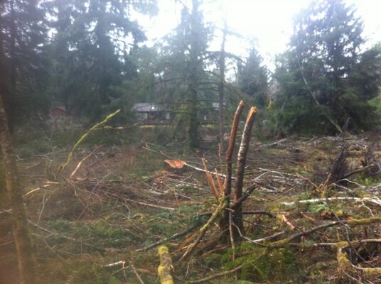
While fishing the Lewis & Clark yesterday, I saw with my own eyes how close the clear cuts got to the stream - they were within a couple hundred feet in places, and of course most of the cuts were at higher elevations, and bare hillside in places. I can only imagine how muddy that river will get with a good rain - and there is a lot of spawning gravel downstream of those cuts.
With groups like the NFS filing law suits to close hatcheries, and budget cuts causing fewer plants from the hatcheries still open - and logging operations allowed to rape the upper reaches of the rivers - the future of these fisheries seems pretty damn bleak. Seems the law suits are aimed at the wrong bodies - sue the timber companies, logging operations, and forestry departments first and make them leave a bigger buffer. We have to fix the health of the rivers before we point fingers at hatcheries for polluting the gene pool.
Every year the Wilson gets blown out by mud slides - mud slides caused largely because of the logging along the tributary streams.
With millions of acres of timber available for harvest - why can't we protect the streams better? The Federal government owns millions of acres of timber that they could allow logging on, as do the states. Spread it out, protect the streams, protect the habitat, and protect the fish.
Thanks to Google Maps satellite view - you can clearly see that there's clear cut operations going on right up at the head waters of the Tualatin, Gales Creek, the Lewis & Clark and Youngs rivers - and a number of other rivers. I'm not against timber cutting, or clear cutting for that matter - but it burns my arse that they cut so close to the streams. It's proven that these streams need a wider buffer zone - so when I see the tell tale signs where the guy lines for a yarder have been placed and trees drug through - it burns my butt. It's pretty easy to tell when you're looking at the map - the landings are a little clear spot with arrow straight spider legs coming off of them, and you can clearly see on Gales Creek, where they've not only cut up to the creek in places, but they're running wires over the creek.
It doesn't matter that these streams may only be a few feet wide up there - that's where the stream begins and it's important to the health of the stream. Choking the head waters with sediment and mud from a clear cut sure is not the way to a healthy stream. And what happens when the rain comes?
While fishing the Lewis & Clark yesterday, I saw with my own eyes how close the clear cuts got to the stream - they were within a couple hundred feet in places, and of course most of the cuts were at higher elevations, and bare hillside in places. I can only imagine how muddy that river will get with a good rain - and there is a lot of spawning gravel downstream of those cuts.
With groups like the NFS filing law suits to close hatcheries, and budget cuts causing fewer plants from the hatcheries still open - and logging operations allowed to rape the upper reaches of the rivers - the future of these fisheries seems pretty damn bleak. Seems the law suits are aimed at the wrong bodies - sue the timber companies, logging operations, and forestry departments first and make them leave a bigger buffer. We have to fix the health of the rivers before we point fingers at hatcheries for polluting the gene pool.
Every year the Wilson gets blown out by mud slides - mud slides caused largely because of the logging along the tributary streams.
With millions of acres of timber available for harvest - why can't we protect the streams better? The Federal government owns millions of acres of timber that they could allow logging on, as do the states. Spread it out, protect the streams, protect the habitat, and protect the fish.