Ross Island plunking

F
Fishpdx
Is this a good spot? I'm might target some bass and crappie and wondering if that ross island slough (east side of ross) will have some salmon or steelhead? Im happy they have the two rod legal for salmon till july!
 
bass
bass
The slough certainly looks like it would be a good bass spot - especially a winter spot but I have never heard of anyone plunking there. I guess that either it is that since RI is only accessible by boat that if you have a boat that there may be better spots to plunk or it is a super secret, zipper lip, hot spot :)
 
F
Fishpdx
bass said:
The slough certainly looks like it would be a good bass spot - especially a winter spot but I have never heard of anyone plunking there. I guess that either it is that since RI is only accessible by boat that if you have a boat that there may be better spots to plunk or it is a super secret, zipper lip, hot spot :)

Lol , I ride my bike there and see a couple bank spots.
 
bass
bass
I always thought that there was not a bridge to the island. I do not see one on google maps. How do you get there?
 
D
DrTheopolis
I believe people troll the east side for springers (never done it myself). I couldn't tell you about depths and distances, though. But heck, if you're bass fishing, might as well chuck a plunking rig out there, too.
 
F
Fishpdx
You can Park at Oaks Amusment park and take the trail either on bike or walk, and just look for some spots you can get down to, there's a couple there. Or You can google sand and gravel company ross island and walk from there. Lot's of google bass spots and tons of carp.
 
F
Fishpdx
DrTheopolis said:
I believe people troll the east side for springers (never done it myself). I couldn't tell you about depths and distances, though. But heck, if you're bass fishing, might as well chuck a plunking rig out there, too.

I had the same thought , why not? trying wont hurt me.
 
bass
bass
I guess you are fishing from the East riverbank and not the island itself then. I thought you were referring to fishing off of the island itself.

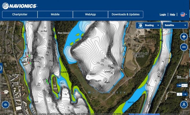
You can see the depth of that channel from the Navionics maps: http://webapp.navionics.com/#@12&key=aqrtGfrtkV

If you click the little circle on the bottom left and then select sonar charts you can get a finer resolution (although sometimes inaccurate) look at the depths. I usually flip back and forth between the two views and kind of average them together in my head.
 
tbrinks
tbrinks
bass said:
I guess you are fishing from the East riverbank and not the island itself then. I thought you were referring to fishing off of the island itself.

You can see the depth of that channel from the Navionics maps: http://webapp.navionics.com/#@12&key=aqrtGfrtkV

If you click the little circle on the bottom left and then select sonar charts you can get a finer resolution (although sometimes inaccurate) look at the depths. I usually flip back and forth between the two views and kind of average them together in my head.

Good advice bass. The SonarChart button shows the best detail. Another thing I do is add the satellite overlay so I can visualize things better. The satellite view is available with the Navionics Platinum+ and HotMaps Platinum cards for your graphs. Those cards are $30 off right now until the end of the month, by the way.

Screen Shot 2016-04-05 at 9.48.20 AM.jpg
 
P
pinstriper
My Hook 4 came with the nav+ card, but I havent used it yet. Are you guys getting those views on your FF, or just on the pc ?


Sent from my iPhone using Tapatalk
 
bass
bass
I just have the crappy built in maps on my HB597. I only look at the charts on my PC before I go out and fish. One thing that bugs me about he sonarcharts is that a lot of the depths seem way off on the Willamette. The water is well over 100' deep around George Rogers park and up by Hogg Island and they are off by a good 30-40'. Also, they show the bottom coming up to about 30' deep in that section which is way off. The normal charts seem more accurate in that region.

I wish I had one of the new garmin units that creates the topo map while you are on the water. Just drive back and forth and it creates a map with 1' contours. That seems really cool.
 
D
DrTheopolis
Man, you guys. If I'm on a boat, and the depth finder mostly works, I'm happy.
 
bass
bass
DrTheopolis said:
Man, you guys. If I'm on a boat, and the depth finder mostly works, I'm happy.

Well, my excuse is that I have a PhD in electrical engineering, I am fascinated by the new technology and have a built in desire to have as much information as possible at my fingertips.
 
tbrinks
tbrinks
bass said:
I just have the crappy built in maps on my HB597. I only look at the charts on my PC before I go out and fish. One thing that bugs me about he sonarcharts is that a lot of the depths seem way off on the Willamette. The water is well over 100' deep around George Rogers park and up by Hogg Island and they are off by a good 30-40'. Also, they show the bottom coming up to about 30' deep in that section which is way off. The normal charts seem more accurate in that region.

I wish I had one of the new garmin units that creates the topo map while you are on the water. Just drive back and forth and it creates a map with 1' contours. That seems really cool.

Not sure about the Willamette, but the SonarChart data is being updated everyday and will adjust. As far as the live mapping, you can do that with Navionics with their SonarChart Live. I have done it with my Lowrance HDS gen2s and the wifi module and also with something called the T-Box from Vexilar connected to my Navionics app. It's awesome and I have mapped some tiny lakes that are in the middle of nowhere.
 
tbrinks
tbrinks
pinstriper said:
My Hook 4 came with the nav+ card, but I havent used it yet. Are you guys getting those views on your FF, or just on the pc ?


Sent from my iPhone using Tapatalk

I am able to see the sat overlay on my laptop, Navionics mobile app and Lowrance units. To get them on your graph you need the Navionics Platinum cards. The Navionics+ is an awesome card and gets the same 1ft contours and community edits, but does not have the overlay or 3d view feature.
 
P
pinstriper
bass said:
Well, my excuse is that I have a PhD in electrical engineering, I am fascinated by the new technology and have a built in desire to have as much information as possible at my fingertips.

Dr. Theopolis, meet actual Dr. Bass.
 
bass
bass
tbrinks said:
Not sure about the Willamette, but the SonarChart data is being updated everyday and will adjust. As far as the live mapping, you can do that with Navionics with their SonarChart Live. I have done it with my Lowrance HDS gen2s and the wifi module and also with something called the T-Box from Vexilar connected to my Navionics app. It's awesome and I have mapped some tiny lakes that are in the middle of nowhere.

Sounds pretty awesome. I think that is where I see a ton of value in the self mapping units. Being able to map smaller waters would be a cool feature. Back in graduate school a friend and I used to dream about this capability. The other thing we used to dream about was having a sonar coupled to your trolling motor and being able to have the boat follow a drop off or a depth. I think units may be able to do that now.
 
D
DrTheopolis
pinstriper said:
Dr. Theopolis, meet actual Dr. Bass.


No kidding -- I just play a Dr on the internet (and not particularly well, at that).
 
tbrinks
tbrinks
yes the technology is there for that, its a great time to be a fisherman. I love the Navionics SonarChart Live. I mapped a small lake that was literally a blue screen before and now it is 90% mapped and that was just from mapping while I fished a few times.
 

Similar Threads

Top Bottom